UCOST Home --> Our Work
ATLAS
Preparation of Resource Atlas for Himalayan State of Uttarakhand
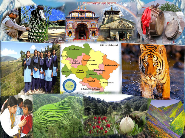
Uttarakhand also referred to as
Devbhumi meaning "Land
of Gods" being one of the Himalayan states and presence of
pilgrimage centers. Uttarakhand has a total area of 53,483
km2 of which 86% is covered by mountains and 65% by forest.
The state is known for its natural beauty comprising a
variety of landscapes, complementary nature of its
geography, economy, culture, language and traditions,
pilgrimage center, educational and scientific institutions
and above all the human resource provides bases for
developing the state as a model of sustainable development.
The state has strong natural resource base of forests and abundant biodiversity, which has to be utilized judiciously for the sustainable development. Economy and Ecology have to go together in order to take care of necessities of human society and fragility of ecosystem. But still we do not posses any centralized resource database for all districts of the state. As the state is accelerating its pace of development, it is imperative to utilize its resources optimally employing all section of human resources. It is also evident that now environment and its sustainability are an issue of concern. Uttarakhand State Council of Science and Technology (UCOST) realizing this need of the hour and therefore proposes to create a resource atlas for the state and developing a resource database in future.
Objective
- The uniqueness of the mountain and environmental specificities of Uttarakhand state will be collected, collated and a scientometric approach be devised to establish a link between the ecological and economic concerns of the region.
- General data on various aspects of environmental resources as well as other parameters which will be collected and compiled.
- Publication & Digitalization of the Resource Atlas with brief details of each districts of the Uttarakhand to accessible for wider masses like Scientist, Researchers, Policy makers and for general public.
Area Covered
- The Resource Atlas will be generated individually, for each of the thirteen districts of Uttarakhand state.
Major Highlights
- It is proposed to include sections like: District at a glance, Topography, Land and people, Soil, Climate, Education, Health, Forest and Wildlife, Agriculture, Water, Energy, Mineral, Industries, Tourism, Transport and communication etc.
- Preparation of maps on Land Use/Land Cover, Water Bodies, Lithology, Minerals, etc providing usable geographic data and information.
Activities
- Data from Open Access Database and through various resources available in the Internet is being accessed.
- The secondary data included in the preparation of the resource atlas is being compiled from divisions within various government and non-government departments and internet access.
- Preparation of a resource directory.
Meetings
- The first internal review meeting was held on 19 July.
- The second internal review meeting was held on 27 July.
- A project review meeting was held with Dr. Piyush Joshi regarding the challenges and the future plans of the project on 4-09-2017.
- Review meeting was held with Joint Director Dr. B.P. Purohit and Dr. Piyush Joshi on 14.11.17.
- Review meeting was held on 15th Feb, 2018 with Dr. Piyush Joshi regarding the future perspectives and progress of the project.
Outcomes
-
Data Base Creation: The Quantitative as well as Qualitative database which will be designed and developed during the project, will provide important and specific details of each districts of the state.
-
GIS Maps of the Location: The GIS map of the 13 Districts will also be published, the Resource Atlas will contain all the necessary maps of the state with the parameters/sections which will be covered in the preparation of the Resource Atlas.
-
Serves as a guide: The researcher and academicians to find a base for carrying out new research initiatives.
-
Climate Change and Local Issue: It serve as a baseline report for forecasting changes in climatic patterns over last few years and determining impacts of such changes.
-
Policy Recommendations and planning: Resource Atlas will prove an excellent database for our policy makers and planners thereby providing recommendations for the development process.
-
Resource Atlas: A compiled and updated report of all the resources available in the states, particularly in each district will be developed by the UCOST, and this atlas will be first of its kind.
If you find any broken link please inform us !
Social Media Links